← Norway
NORWAY · CITY

Geiranger

  • City
  • UNESCO Fjord
  • Seven Sisters Waterfall
  • Hairpin Roads
  • Cruise-Ship Village

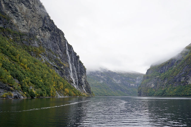
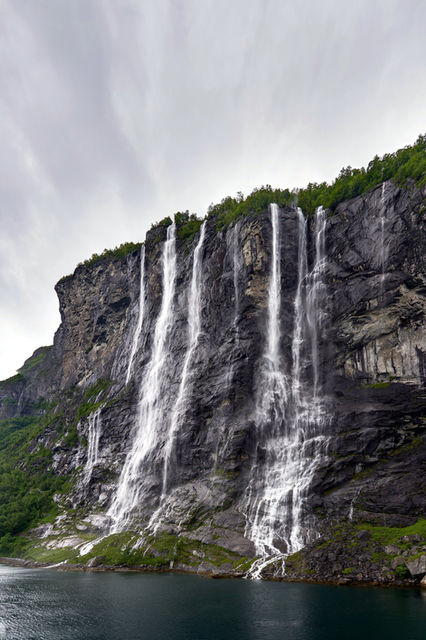
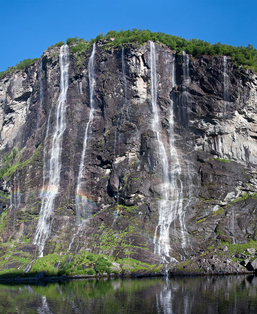
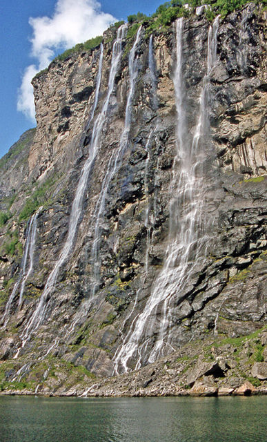
The Seven Sisters falling in white threads off a sheer green wall, a ferry cutting a slow line up the emerald water below, and the switchback road behind you climbing into cloud.

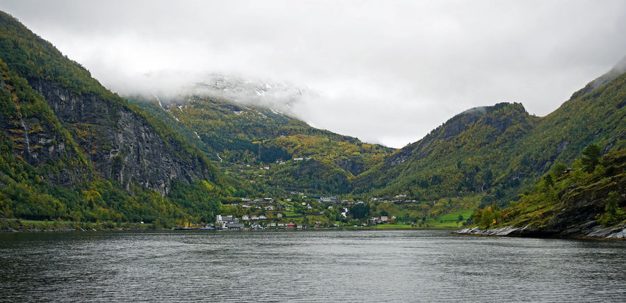
Geiranger is a handful of houses at the head of the most famous fjord in Norway, where waterfalls pour off cliffs a thousand metres high and the road in drops through hairpin after hairpin. It is tiny, seasonal and swamped by cruise ships at midday — and, caught early or late, one of the most staggering places in Europe.

▸ Discover

About Geiranger

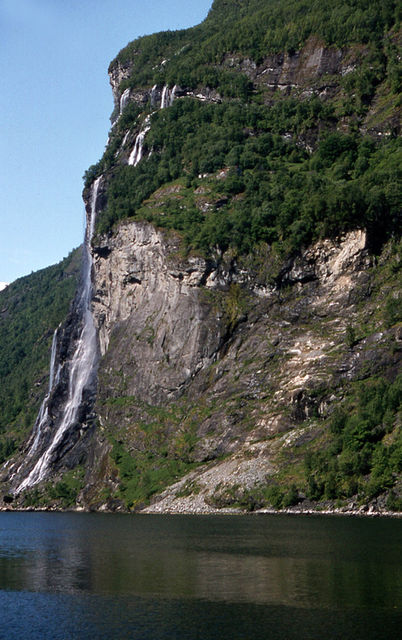
Geiranger sits at the very end of the Geirangerfjord, a 15-kilometre arm of blue-green water walled by near-vertical mountains in the Sunnmøre region of west Norway. The fjord is a UNESCO World Heritage Site (with the Nærøyfjord further south), and it earns it: abandoned mountain farms cling to ledges, and famous waterfalls — the Seven Sisters, the Suitor, the Bridal Veil — drop straight into the water. The village itself is little more than a quay, a church, a fjord museum and a scatter of hotels, hemmed by mountains and reached only by steep mountain roads (shut in winter) or by the fjord. That isolation is the whole point; it is also why the summer cruise crowds hit so hard in so small a place.

Why go

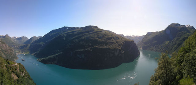
Nowhere gives you the classic Norwegian fjord — sheer walls, plunging waterfalls, a ribbon of ferry-cut water — as concentrated and as accessible as Geiranger. You can see it from a boat at water level, from the Flydalsjuvet overhang above the village, and from the road viewpoints of Dalsnibba and the Eagle Bend, all within a morning. For fjord scenery at full volume, this is the one.

Don't miss

  • The Seven Sisters, the Suitor and the Bridal Veil waterfalls, seen from the fjord
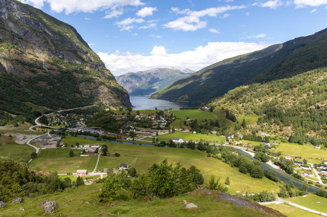
  • The Flydalsjuvet viewpoint over the village and the fjord
  • The Dalsnibba mountain road and Geiranger Skywalk high above the fjord
  • The Ørnevegen (Eagle Road) hairpins and Ørnesvingen viewpoint
  • A fjord cruise or kayak on the Geirangerfjord itself

Signature experiences

The fjord from the water — The Geirangerfjord is best met at water level, where the walls tower and the waterfalls come alive. The regular Geiranger–Hellesylt car ferry doubles as a superb hour-long fjord cruise, passing the Seven Sisters, the Suitor opposite and the Bridal Veil, with the abandoned cliff-farms of Skageflå and Knivsflå pointed out on the way. Dedicated sightseeing boats and small-group RIB safaris get you closer still. However you do it, an hour on the fjord is the trip. **Kayaking under the waterfalls** — For the quiet version, take a sea kayak out from the village and paddle along the base of the cliffs, under the spray of the falls, with the ferries and cruise ships reduced to distant shapes. Guided trips and rentals run through the summer from the waterfront, and being down at the waterline in a small boat is the most intimate way to feel how vast the place is. **The high roads: Dalsnibba, the Eagle Road and beyond** — Half of Geiranger's drama is in the getting there. Drive (or bus) up the Nibbevegen toll road to the Dalsnibba skywalk for the aerial view, and out over the eleven bends of the Ørnevegen (Eagle Road) with its viewpoint plunging onto the fjord. To the north the same Norwegian Scenic Route leads on toward the famous hairpins of **Trollstigen** — which reopened for the 2026 season in late April after major rockfall-safety work, though it still closes over winter and can shut at short notice in heavy rain, so check before you plan around it. **A hike to an abandoned fjord farm** — For walkers, the classic is Skageflå: a boat drops you at the foot of the cliffs and a steep marked path climbs to a spectacularly sited abandoned mountain farm high above the water, with the Seven Sisters across the fjord. Shorter walks reach Storsæterfossen, a waterfall you can actually walk in behind. These are proper mountain hikes — boots, water and a head for heights required. **Flydalsjuvet and the light** — Beat the ships to the Flydalsjuvet ledge above the village early or late in the day, when the low sun rakes down the fjord and the cruise traffic has thinned. It is a five-minute detour off the road and the most reliable great view in Geiranger — the one that turns up on every postcard, and better in person.

Neighbourhoods

Geiranger neighbourhood by neighbourhood — the character of each and who it suits.

  • Geiranger village & the quay

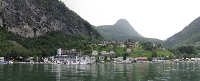
    The small settlement at the fjord's head — a cruise and ferry quay, a handful of hotels and cafés, the church on the slope and the Norwegian Fjord Centre museum. Everything crowds the last flat ground before the mountains take over.

    Why go
    The base for every boat, bus and walk, and the point where the fjord's scale hits you at water level.
    Best for
    Fjord cruiseskayakingthe fjord museumarriving by ferry
    Known for
    The cruise quay and the Hellesylt car-ferry berth, the Norsk Fjordsenter (Norwegian Fjord Centre), the village church, and the start of the mountain roads.
  • Flydalsjuvet & the fjord viewpoints

    The famous overlook a short way up the road toward Stryn, where a rock ledge juts over a near-sheer drop to the village and the fjord below — the postcard shot of Geiranger.

    Why go
    The single most famous view of the fjord, and easy to reach by road or a short uphill walk.
    Best for
    Photographythe classic Geiranger viewsunset light
    Known for
    The Flydalsjuvet ledge and its lower photo platform, and the long view down the full length of the fjord.
  • Dalsnibba & the Geiranger Skywalk

    A high mountain summit reached by a toll road (Nibbevegen) that climbs to around 1,500 metres, ending at a viewing platform — one of the highest fjord views in Europe reachable by car.

    Why go
    A god's-eye view over the whole fjord system and the snowfields, from far above everything else.
    Best for
    Panoramasbig-mountain scenerya clear-day drive
    Known for
    The Geiranger Skywalk platform at Dalsnibba, the switchback toll road up, and lingering snow even in summer.
  • Ørnevegen (the Eagle Road) & the north side

    The dramatic sequence of eleven hairpin bends carrying the road north out of Geiranger toward the Eidsdal ferry, with a viewpoint at the top of the climb.

    Why go
    The great drive out of the village and the Ørnesvingen viewpoint straight down onto the fjord and the Seven Sisters.
    Best for
    Scenic drivingviewpointsthe road north
    Known for
    The Ørnesvingen (Eagle Bend) viewpoint, the eleven bends of the Eagle Road, and the onward Norwegian Scenic Route toward Trollstigen.

Views & hidden gems

Best views

  • Flydalsjuvet — the overhanging ledge above the village, the definitive Geiranger view
  • Dalsnibba / the Geiranger Skywalk — the highest road-reached fjord panorama
  • Ørnesvingen (the Eagle Bend viewpoint) — straight down onto the fjord and the Seven Sisters
  • The deck of the Hellesylt ferry mid-fjord, level with the waterfalls

Hidden gems

  • The Skageflå and Knivsflå cliff-farms — abandoned fjord smallholdings only reachable by boat-and-boot
  • Storsæterfossen — a waterfall with a path that leads behind the falling water
  • The Norwegian Fjord Centre — a quiet, genuinely good museum on how people lived on these near-vertical slopes
  • The early-morning hours before the cruise ships dock, when the village and the water are almost empty
  • The "Westerås" farm café up the hillside, a working farm with fjord-view tables away from the quay

Food & drink

Geiranger eats simply and for a captive summer crowd, so expect fjord-view hotel dining rooms, a few cafés and farm kitchens rather than a scene. What it does well is local and seasonal: fjord and mountain produce, trout and salmon, cured meats, mountain-farm goat's cheese and berries, and the ever-present Norwegian waffles with brown cheese and jam. A working hillside farm or two serve lunch with a view that no restaurant could better. Prices are high and options thin out sharply outside the May-to-September season, so plan meals around the hotels and cafés that stay open.

  • Fjord trout and salmon — the local fish, simply cooked
  • Norwegian waffles (vafler) with brunost brown cheese and jam
  • Mountain-farm goat's cheese and cured meats (spekemat)
  • Cloudberries and wild berries in late summer
  • Rømmegrøt — traditional sour-cream porridge, a mountain-farm dish
  • Aquavit — the caraway spirit, the traditional accompaniment to a fjord meal
Dietary notes

Choice is limited in such a small village; the hotels and larger cafés will cover vegetarian and gluten-free with notice, but vegan, halal and kosher options are minimal — self-cater from the small village shop if you have strict requirements, and don't count on much outside peak summer.

Geiranger in photos

▸ Getting around

Getting around Geiranger

The village is walkable end to end. Beyond it you need a car or the summer sightseeing buses and boats — the viewpoints (Flydalsjuvet, Dalsnibba, the Eagle Road) are spread along mountain roads, and the fjord itself is reached from the quay. There is no local public transport of note; plan around the ferry, tour boats and your own vehicle.

On foot within the village; by car or tour for the viewpoints and the fjord. Flydalsjuvet is minutes above the village; Dalsnibba and the Eagle Road are each a scenic drive of their own. The fjord's cliff-farms and waterfalls are reachable only by boat.

▸ Plan your days

Suggested itineraries

Ready-made day plans for Geiranger — from a single day to a long weekend.

One day

Arrive by the Hellesylt car ferry so your first hour is a fjord cruise past the Seven Sisters. From the quay, take a short kayak or sightseeing boat, then drive up to Flydalsjuvet for the classic view and on up the Dalsnibba toll road to the skywalk if the sky is clear. Leave over the Eagle Road hairpins in the late afternoon, stopping at the Ørnesvingen viewpoint on the way out.

Two days

Give day two to the mountains and the water at a slower pace. Hike to the Storsæterfossen waterfall to walk behind the falls, or take the boat-and-boot route up to the abandoned Skageflå farm high above the fjord. Spend the afternoon on the fjord by kayak, and the evening at a hillside farm café with the light going long over the water.

Three days

Use day three to explore outward on the Norwegian Scenic Routes. Drive north over the Eagle Road toward Trollstigen and the Sunnmøre Alps (weather and openings permitting), or west toward Ålesund's Art Nouveau town and the coast, treating Geiranger as the fjord anchor of a wider western-Norway loop.

▸ What you'll do

Insider tips

  • Getting to Geiranger is half the experience — arrive by the Hellesylt ferry or over the Dalsnibba/Eagle roads rather than the fastest way, and build the drive into the day.
  • Parking at the village and the popular viewpoints fills at midday in summer; come early.
  • Many services, roads and hotels are strictly seasonal — check what's actually open before a shoulder-season or winter trip.
  • Fuel up and stock any supplies before you arrive; the village shop is small and prices are captive.
Explore

Explore the area

Interactive area map
Map coordinates coming soon

This place is missing lat/lng — waiting on the next Wix sync.

Do

Local attractions & tours

Skip-the-line tickets and small-group tours in Geiranger — compare across our partners.

▸ Budget

What it costs in Geiranger

Backpacker
roughly kr 700–1,200 a day.
Mid-range
roughly kr 1,800–3,000 a day.
Luxury
kr 4,500 a day and up.
Cash vs card
Norway is effectively cashless — tap a card or phone everywhere, including the ferry and the kiosks. You rarely need cash.
Tipping
Not expected; round up for good service if you wish.
▸ When you'll go

When to visit Geiranger

Spring

What to expect — The mountain roads (Dalsnibba, the Geiranger road, Trollstigen) reopen through late spring as the snow clears — often not until May — and waterfalls run at full snowmelt volume. Some services are still winding up.

What's best — The falls at their most thunderous, fewer cruise ships early in the season, and fresh snow still on the peaks above green valleys.

Summer

What to expect — The full, brief high season — every boat and road open, long daylight, and cruise ships in the fjord bringing thousands of day visitors to a village of a few hundred. Midday is crowded; the roads and viewpoints busy.

What's best — Everything is running — ferries, cruises, kayaks, the high roads and the hikes — and the light lasts late into the evening once the ships have gone.

Autumn

What to expect — The crowds fall away from September, the hillsides turn gold, and the high roads begin to close again as the first snows arrive. Cooler, quieter, shorter days.

What's best — Autumn colour on the fjord walls, near-empty viewpoints, and the last of the ferries and cruises before winter shuts the village.

Winter

What to expect — Geiranger largely closes. The mountain roads over Dalsnibba and to Trollstigen shut, most hotels and services stop, and access is limited. Snow, short days and a silent fjord.

What's best — A rare, stark beauty for the very few who come — but plan carefully, as most of the village and its roads are shut.

▸ Know before you go

Know before you go

Honest swaps

Skip paying for a separate sightseeing cruise if time is tight → the scheduled Geiranger–Hellesylt car ferry is itself a superb fjord cruise for a fraction of the price.

Skip staying in the village if it's booked or dear → base in Hellesylt, Stranda or Ålesund and come in for the day by ferry or road.

Skip fighting the midday cruise crowds at Flydalsjuvet → go early morning or evening, when the ships have gone and the light is better.

Skip driving up Dalsnibba in cloud → it's a toll road to a viewpoint; check the summit webcam/forecast first, or you'll pay to stand in fog.

Crowds & timing

Cruise ships dock mid-morning and leave late afternoon in summer; the village is transformed and then emptied. Plan boats and viewpoints for early or evening.

The high roads and the ferry are seasonal — the Dalsnibba road and Trollstigen are shut outside roughly late spring to early autumn. Check openings before you plan a route around them.

Reine's-style photo spots aside, Geiranger's viewpoints are roadside — arrive off-peak for parking as much as for the light.

Local rules & etiquette

The Geirangerfjord is a UNESCO site with tightening rules on cruise emissions and boat traffic — respect marked areas and the working farms; the mountain-farm land is private.

The hikes (Skageflå, Storsæterfossen) are real mountain routes — proper footwear, water and a weather check; don't underestimate them.

Weather turns fast in the mountains; carry a waterproof and warm layer even in July.

Money

Tap-to-pay everywhere; cash is essentially unnecessary. Decline "pay in your home currency" on card terminals — choose Norwegian kroner.

After dark

This is not a nightlife village — evenings are fjord-view hotel bars, a late walk to the quay, and the long summer light on the water.

The best "after dark" in high summer is that it barely gets dark at all — use the late evening for the emptied viewpoints.

In shoulder season the village is very quiet after the day boats leave; bring a book.

▸ Ready to book your trip?

Getting there

Geiranger has no airport or railway — you come by fjord or by mountain road. The scenic way is the Geiranger–Hellesylt car ferry, a fjord cruise in its own right; the road ways are the Dalsnibba/Langvatnet route from Stryn or the Eagle Road hairpins from the Eidsdal ferry, both seasonal and shut in winter. The nearest airport is Ålesund, Vigra (AES), roughly a couple of hours away by road-and-ferry; buses run from Ålesund in summer.

Book

Ready to book your trip?

Flights, airport transfers and car hire — search and compare without leaving the page.

▸ Trip extras
Book

More trip extras

Parking, holiday extras, and more — coming soon.

Coming soon

We're lining up parking, holiday extras and activities you'll be able to add to any trip from here.